|
Trip Report: Circumambulation of Powell Plateau October 7-17, 2002
Day 1: Swamp Point to Stina Canyon Day 3: Thunder River, Detour to Lower Tapeats, Deer Creek Day 4: Lower Tapeats to Switch Level Canyon Day 5: Switch Level Canyon to Fossil Rapids Day 6: Fossil Rapids to Mushroom Rock Day 7: Around Explorer’s Monument Day 8: Walthenberg and Hakatai Canyons Day 10: North Bass Trail to below Swamp Point
Day 1: Swamp Point to Stina Canyon
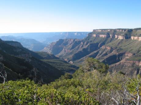
On Monday morning, October 7, 2002, I headed down the trail at Swamp Point on the North Rim of the Grand Canyon to begin a circumambulation of Powell Plateau. The plateau rose in front of me, a long and narrow sky island with a band of Kaibab limestone cliffs around its rim. I was eager to go up there and see the virgin Ponderosa Pine forest and search for Anasazi surface ruins, but first I was going to circle it the long way.
Looking Southwest from Swamp Point, Powell Plateau on Right
Besides the normal backpacking gear I had a permit good for 11 days, 13 pounds of food, 4 liter bottles of water, two empty 96 oz. Nalgene flexible canteens, salt tablets, a satellite phone, an umbrella, and, most importantly, two full vials of Tylenol and Advil which in combination would approach the potency of a prescription pain killer. The permit had been annotated with the not unusual National Park Service warning ‘EXCESSIVELY DANGEROUS HIKE! HIKER INSISTED ON ITINERARY.’
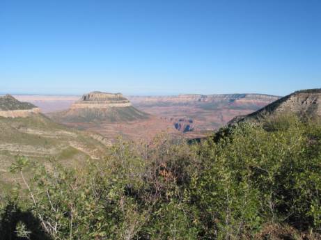
Looking Northwest from Swamp Point. Streamboat Mountain is to left of Saddle Canyon
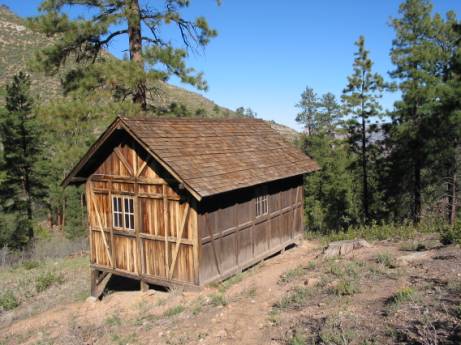
The trail down from Swamp Point is a series of well graded switchbacks descending about 800 feet to Muav Saddle. At the bottom there is a trail junction. The North Bass trail goes off to the left to the Colorado River; straight on leads up to Powell Plateau, the trail clearly visible on the treeless slope; and the trail to the right leads to ‘Teddy’s Cabin’, named after Teddy Roosevelt even though he never slept there, although he did supposedly camp on the site while hunting mountain lions on Powell Plateau.
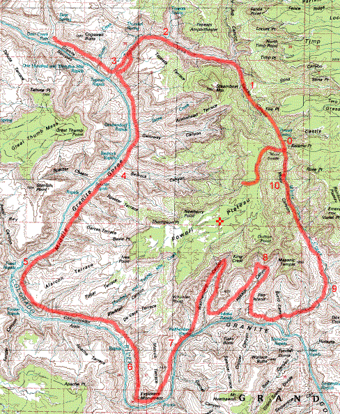
Approximate Route with Campsites Numbered by Day
The plan was to go right, descend Saddle Canyon, go around Powell Plateau mainly along the Colorado River, and eventually work my way back up the North Bass trail, a map distance of around 40-50 miles. The trip was based on “Circumambulation of Powell Plateau” from “Loop Hikes in the Grand Canyon” by George Steck. He did it in nine days but I knew from past experience that I would need a lot more time than Steck. Another complication was the permit, which only allowed me to camp in certain areas each night.
Four hikers were resting at the trail junction. I asked them about water conditions and they said that they had found water where the guide books had said there would be water, which was encouraging given that 2002 had been a severe drought year in the West. As I turned right at the junction I noted that I would return to that same spot in 10 days.
Teddy’s Cabin
I inspected the cabin, which was clean and tidy with spring beds and no mattresses, then headed down the drainage, pushing through brush in a shallow stream depression. I had planned the trip for October, hoping for cool weather, but the day turned hot, and the temperature was soon up into the nineties.
Although the stream bed stayed dry there was a pool of clear water above the first pouroff -- I would have no water trouble that day. I skirted around the dry fall on its west side and continued on. Pushing through the shrub oak was difficult and I was glad I was wearing long sleeves and long pants despite the heat.
At a bigger pouroff I was forced up the west ridge and over into another drainage. This involved some climbing and bushwhacking to find the way.
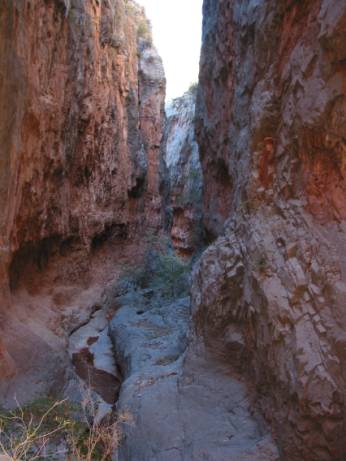
Redwall Gorge
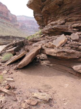
The canyon grew deeper as I descended, and finally turned into a sheer walled gorge as it cut through the Redwall limestone. It was in the Redwall gorge that I encountered the first sheer drop of the trip. I came up to an edge and looked straight down about 12 feet. There was no way around it. I lowered my pack on a rope, threw down my poles, climbed over the side, hung down by my arms, and dropped. Not so bad, I thought, but was glad I didn’t have to climb it.
Soon there was another drop. At this one someone had propped up a log, probably to climb up. I am leery of wood when hiking since it seems to cause a lot of accidents. I lowered my pack by rope and then edged down to the log and tested it. Sure enough it was rotten and no good for a foothold, and furthermore blocked the way for a clean jump. I somehow kicked it enough out of the way to get around it and jumped down.
It was getting toward the end of the day when I reached the obstacle pool that I had read about. It was muddy and had steep walls on both sides. Everything in my pack was in waterproof stuff sacks, so I decided to just jump in. I edged down the channel in the rock and slid in to the water. I was relieved to touch bottom with the water up to my chest. I worked my way across the pool with my poles testing the bottom. The exit was slick and I fell backwards trying to get out, but finally made it. I was now dripping wet and had about an hour of daylight left.
Pressing on I came to another pool, this one with a steeper descent down a slimy chute with a trickle of water. I slid down this and splashed into the water, which was not as deep as the previous pool.
Then I came to a really scary slide and drop and said to myself, “I am not going down that.” Luckily there is a high bypass to the left. The way is steep and covered with sharp loose rocks and requires care where you place your feet. Once you get back down to the streambed and go a little further Stina canyon enters from the right. By the time I reached it I was more than ready to camp.
I looked around for high ground, mindful of the danger of flash floods, but found nothing level so settled on a spot on the bank about 10 feet above the dry creek bed. Up Stina Creek about 100 feet there is a large cottonwood tree with a spring at its foot with excellent clear water. Back at camp I strung up a clothesline and put everything up to dry and was happy to have dry clothes. Now that the first day was over I chuckled to myself that I was certainly getting my money’s worth ($5/day for the permit) in terms of pure terror, isolation, and dumbfounding beauty.
The sun went down at 6:00 pm and wasn’t going to come up until 6:15 am. I set the alarm for 4:30 am because I didn’t want to waste any daylight of the relatively short day, and also because I wanted to hike as much as possible in the morning before the sun hit the canyon bottom. This is the pattern I would repeat for the rest of the trip, eventually moving to a 4:00 am wakeup. Soon I was snoozing thanks to an Advil/Tylenol cocktail, sheer exhaustion, and the sound of wind on rock.
Day 2: Tapeats Creek
Despite the early wakeup I didn’t leave camp until 8:00 am. The canyon widened out below Stina and the going was easier than the day before. Crazy Jug canyon entered on the right at 8:50.
Journal entry: “Had a good laugh this morning over yesterday’s descent. It’s not like I had a lot of choice. I wish I had a photo of my face as I slid into the pool.”
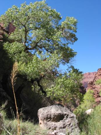
Cottonwood
Around noon I reached a spring coming out of a rock in streambed and suddenly I was in a wet canyon; brown gave way to green and birds pecked at the edges of the pools. A few big cottonwoods appeared. I am very fond of cottonwoods in canyons, which are often stunted and twisted from floods but somehow manage to survive.
Coming up to one of the many minor rock descents I saw no easy way down. Disregarding my misgivings about wood from the day before, I lowered myself backward down the rock holding onto a tree branch. The branch broke and I fell onto my back with my head in the water, for some reason unharmed. I realized that my judgment was slightly impaired by tiredness and dehydration and that I would have to be more careful.
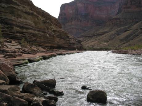
At around 1:30 pm I heard a roar echoing off the cliffs in the distance and soon was at the junction of Tapeats creek, a torrent of swift, clear water entering from the right. The route would now follow Tapeats Creek to the Colorado River.
Soon I had to cross it. It wasn’t stunningly cold, but it was swift and deep enough to be frightening. I lengthened my poles and crossed facing upstream with three points in contact at all time and my boots on. I wouldn’t want to go barefoot in Tapeats Creek or cross it in the Spring.
On a high bypass to the left I was confused by cairns above and below me, but finally realized that I would have to descend a cliff and into the stream gorge for some extensive wading. In what was now becoming a familiar routine I lowered my pack on a rope and scrambled down. In the creek I took my time avoiding the deeper spots, mainly staying near one wall or the other.
At around 4:00 pm I reckoned that I was about a mile away from Thunder River and could go no further that day due to permit restrictions.
Day 3: Thunder River, Detour to Lower Tapeats, Deer Creek
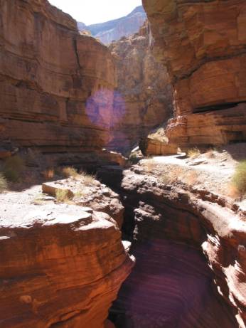
Thunder River Junction with Tapeats Creek
At 7:20 am I reached the junction of Thunder River coming in from the right and the Thunder River trail. I crossed to the west side above the junction to avoid the doubled torrent. From here to the Colorado River is a well established trail, often on both sides of the creek. I crossed several times looking for ruins but couldn’t find any. At about 8:30 am the creek started to go down in a gorge and there was a climb down.
For some reason my permit had been changed to the Lower Tapeats campground at the Colorado River for the night. This was out of the way, since to keep going I needed to contour around the east side of the Tapeats gorge and the campsite trail is on the west side. However, I wanted to day hike to Deer Creek along the Colorado River so it didn’t matter. I could have also gone up the Thunder River trail to Surprise Valley and over to Deer Creek, but I wanted to ditch my pack weight at a campsite.
The trail along Tapeats gorge to the Colorado stays high until the end and then descends steeply 300 feet to the river. Here there was a raft party and some hikers. A lame turkey was hobbling from group to group begging food. I set up the tent and hung the food bag inside and was hightailing it downriver towards Deer Creek by about noon.
The route to Deer Creek starts along the river, goes over a rock obstacle, and eventually climbs above the Tapeats sandstone onto the Tonto shelf, with cliffs below and above. This was my first encounter with the Tonto, which was to be the major thoroughfare for the rest of the trip. The sun was at full force and it was hot and slow contouring around the minor drainages. I crawled under a rock at one point to rest. I deployed my umbrella to good use; once out of the sun the desert air does not seem that hot.
The trail is fairly easy to follow, but like all unmaintained trails it left me guessing a few times. At the end it goes inland and descends into Deer Creek valley right where the creek drops into its gorge. From the high vantage point of the trail two ruins are quite visible on the west slope above the creek. The lower ruin has a circular area which might have been a kiva.
Deer Creek Gorge
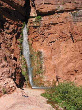
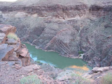
The Deer Creek gorge is narrow. There is a path along a ledge on the west side. The clear water roars below and cliffs rise above to the blue sky. Anasazi handprints on the rock warn that you are approaching the inner sanctum. After a while you come out onto a ledge overlooking the Colorado River and the creek plummets one hundred feet into a pool below.
Deer Creek Falls
I climbed down to the foot of the falls, stripped down, and stood in the icy horizontal blast where the water thunders into the pool. Although it was a hot day I was soon shivering.
Unfortunately, I was now out of time. It was approaching 4 pm, it would take three hours to go back, and it would be pitch dark at 7 pm. So I bid farewell to Deer Creek, promising myself once again to return someday.
It was dark by the time I made it back to camp and I had to use my headlight at the end. A tent was pitched next to me and the occupants were asleep. A rafter offered me dinner, which I deemed generous, but I passed.
Day 4: Lower Tapeats to Switch Level Canyon
The tent next door was still sleeping when I was up at 4:30 the next day and off at 6:40 am. I wasn’t sure where the trail branched off to go upriver, but I found it just where Tapeats Creek begins its descent into the gorge. The crossing was wide with a gravel bottom and was one of the easiest.
On the way to Stone Creek I encountered a group of hikers. These would be the only hikers I saw along the river. The leader asked me if I was alone and I said yes, hoping I wouldn’t get any advice. He said, “Easier that way.” Correct. You don’t have to worry about the other person or the pace. All you have to worry about is dying if you make a mistake.
After the descent to Stone Creek I was able to go along the beach, past Galloway Canyon, which was dry, and then up on some crumbly cliffs and a nerve wracking descent back down to the river at 1:15 pm and lunch. This was my first use of river water. I scooped it up in the flexible 96 oz. Nalgene canteens and let it settle before using it (but settling overnight would have been better). I saw some rafts go by.
Journal entry: “Today is cooler than yesterday, 79 degrees in the shade, and the sky is clouding up.” Often on this trip the day would start clear and the sun would be very hot, then the sky would haze up and the heat would lose intensity.
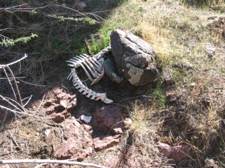
Burro Skeleton
I approached Bedrock Canyon at 2:40 pm. There is a large fallen slab that forms a rock shelter here, and a feeling in the air of ancient human habitation. A burro skeleton lies near the shelter, and I started imagining what the life of a wild burro must be like. The stream was dry. It took me a while to decide on how to go up the far side.
Somewhere along in here I took to attaching each of my water bottles to my pack with a little loop of rope, even though they normally sit securely in their mesh pockets. I guess that tells you something about the terrain.
I stopped about 5:30 pm at the canyon about a half mile past Bedrock that Steck calls “Switch Level Canyon.” Here there was a stream of water in a rock channel and a good campsite. I washed clothes in the channel. A warm breeze blowing down canyon dried them quickly.
Day 5: Switch Level Canyon to Fossil Rapids
Up at 4:00 am and ready by 6:00 but it was not quite light enough to proceed. Journal entry: “Each one of these canyons reaches up through the treacherous Redwall to the sandstone Esplanade. And above the Esplanade reigns Powell Plateau, one mile above where I sit. The trees lining its edge look as small as toothpicks, and its Kaibab limestone cliffs make it appear like an impenetrable fortress.”
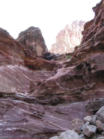
I climbed out and contoured along the Tonto. At 9:30 am I reached 128 Mile Creek canyon. According to Steck’s narrative I went down in the first drainage and looked over the edge only to find a sheer and frightening drop. Luckily someone had scratched an arrow into the dirt pointing up canyon. There I found the way down a deeper drainage.
128 Mile Creek, Looking Up
There is not much room at the bottom of 128 Mile Creek canyon and there is a stench of human feces in the air. I was glad I stayed at Switch Level the night before. I filled up 3 liters of water, figuring I would reach water again soon enough. I could not figure out which drainage opposite was the exit. The one I went up was too steep for comfort, but I don’t know if there was a better one.
I was prepared for the lack of trails after Stone Canyon, but was pleasantly surprised to often find a burro trail up on the Tonto. I was not able to stay on one for long, often losing it when it crossed the chaos of a washed out drainage. But there was a trail, often near the edge of the cliff above the river, and if you could get on it the going was easier. For all I know these trails could have been originally made by the Anasazi over a thousand years ago. I saw many primitive rock shelters and chipped rock artifacts along the way.
Journal entry: “Reached Fossil Rapids 5:30 pm. Should have brought 4 liters of water from 128 Mile canyon. All Tonto, all day, lots of contours.”
I camped on the beach downstream of the rapids. I collected river water and let it settle overnight, but discovered there is a lot more silt downstream of rapids than in the placid sections.
Day 6: Fossil Rapids to Mushroom Rock
In the morning I watched bats dip and dive overhead eating bugs well into the light of dawn.
Journal entry: “Still a little dehydrated from yesterday. Part of the day is along the river, so maybe I will do better today. Left 6:45, arrived Forster Rapids 10:00 am.”
Forster Rapids
Forster Rapids is one of the highlights of the trip. You walk along a sandstone ledge and can almost reach out and touch the tall standing waves of the rapids.
Shelter Above Blacktail Canyon
I reached Blacktail Canyon at 2:30 pm. There were several rock shelters and chipped artifacts on the climb down the nose to the bed. Blacktail is a narrow canyon with spooky looking Tapeats sandstone walls. There were some clear puddles in the streambed. I tried to find a fossil mentioned in the Steck book but a raft trip was playing recorded organ music further up canyon, some kind of “behold the great unconformity” moment, so I left.
Pushing on another mile and a half along the beach I reached the large mushroom shaped rock that marks one of the possible ascents up to the Tonto for the long haul around Explorer’s Monument, the southernmost part of the trip. There is a sandy beach downriver from the rock that is nice for camping and was the last time I was near the river on the trip. I tried to swim but the river is just too cold for me.
Journal entry: “Today was the ‘zenith’ day – the extra day between the five coming and the five going. The day was more perfect than yesterday because it was easier.”
Day 7: Around Explorer’s Monument
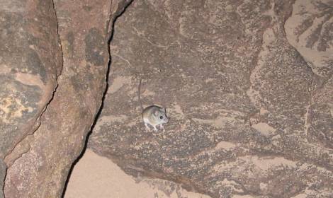
The Mouse
The next morning at breakfast in the dark I was visited by a very persistent mouse that would not take no for an answer. This was the only problem with food and wildlife I had on the trip.
Leaving about 6:15 am I started climbing the cliffs behind the mushroom rock. At one point I found myself crawling along a ledge on my stomach with my pack brushing the rocks above. This was followed by a fear inducing climb.
Explorer’s Monument
The sun soon reached full intensity and I used the umbrella. I rounded Explorer’s Monument at 10:30 am and reached the fault drainage on the other side at 11:30. The fault is very clearly a fault – it splits the rock and you can see that one side has shifted down. Here there was water in a pool and I stopped for lunch. I had started the day with over 4 liters of water and finding this water was a bonus.
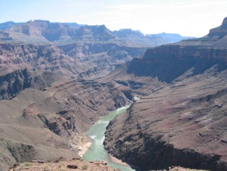
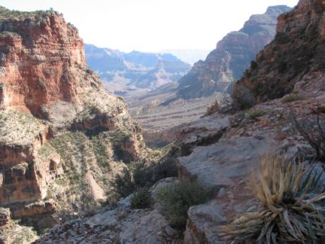
Pushing on along the rim ‘trail’ an incredible panorama unfolded before me. On the left were high unbroken Redwall cliffs. Below was a long stretch of river, gleaming silver at many bends. The inner gorge was crossed with diagonal veins that I had not seen before. I could see a trail winding along on the other side.
It soon became obvious that the land was much drier on this side of Explorer’s Monument. Water was not flowing at the drainage Steck refers to as ‘key spring’, but there was some foul smelling water in a pool. I drank some and my stomach started rumbling, so I kept it in reserve. According to reports this water has given more than one person diahrrea. In retrospect I should have carried all the water I could from the pool at Explorer’s Monument – a lot more than 4 liters.
I stopped at 5:00 pm at dry camp on the cliffs. The mosquitoes were bad but the view was excellent.
Day 8: Walthenberg and Hakatai Canyons
Today brought a long traversal around Walthenberg Canyon as it is too steep to cut across. I was hoping to find some rain pools at the head but when I reached there around noon I could not find any.
By the time I reached Hakatai canyon I was down to one liter of water. Looking down into Hakatai I could see the square mouths of the old asbestos mines. The stream was dry. I could not find the way down. The next day when reading about Burro canyon I found a text passage that implied that the way down Hakatai is at the nose and then in along a ledge under the rim, but I was looking at the map and it showed a line going along the edge and that’s what I was trying to do. I would have liked some latitude-longitude waypoints for many of the canyon descents. Since I was low on water anyway and had plenty of time I decided to contour to the head of the canyon and try to find some water.
Along the Edge
The prickly pear cactuses are thick in this area and my light boots that worked so well in Tapeats Creek were a liability here as the spines kept poking in through the mesh sides. If I did it again I guess I would wear tennis shoes in the wet part and thick and heavy mountaineering boots for the dry parts. At this point my feet had elongated and widened and so the boots were also too tight.
I was finally able to descend into Hakatai in a side drainage almost at the head. It was 5:30 pm and getting dark when hurrying down the slot I found a small rain pool of good water. I knelt down and filled my bottles and whispered “thank you.” Just below the pool was an overhung chockstone. I could jump down but it wasn’t obvious I could get back up, so I camped on a ledge by the pool.
Later that night a half moon shone down into the canyon. Owls hooted in the rocks.
Day 9: To Shinumo Creek
In the morning I had the choice of heading down canyon or bypassing the canyon at the head. Since the chockstone made me nervous, I decided to bypass. The bypass was an ordeal, and I wished I had tried the canyon, but who knows if it would have been better. I saw a large rock shelter at a point between two merging canyons but could not easily get to it.
The east wall of Hakatai is steep and involves lots of contouring around drainages. Even on the bypass I had to walk across several steep rock falls. I was happy to leave it behind.
A thin double layer of red rock rings the Tonto formation in this area. I hiked up to it and have never seen such red or ancient looking rock. I could have been on Mars.
Near Burro Canyon
I approached Burro Canyon with some misgivings because of more vague descent directions, but this time the way was clear. It was a long way down, but I could see Shinumo Creek and its line of green in the distance to motivate me. I finally made it to the clear flowing water about 2:30 pm and onto the relatively well marked North Bass trail. What a relief it was to not have to look for the trail every few minutes.
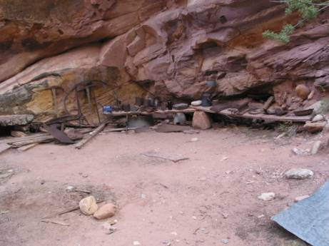
Bass Camp
Approaching the old Bass Camp at 3:45 pm I saw clear evidence of landscaping and was transported back to a different time. I encountered another hiker at the collection of old iron implements, the first hiker I had seen in five days. There are supposedly some Anasazi ruins in this area but I did not see them. I will look more carefully next time.
Journal entry: “Camped below the White, Shinumo junction. There are trees and dirt!” Reached there at 5:20 pm.
Day 10: North Bass Trail to below Swamp Point
Today was the long hike out, a climb of about 4,000 feet. There was some water most of the way, and it did not get steep until the end.
|